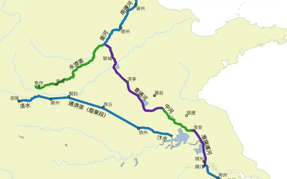
China's Grand Canal consists of sections built in different periods. Long used to carry grain and other goods, it connects several river basins and important cities.
Its routes, navigability, and management systems changed over time. It influenced urban growth while requiring locks, dams, dredging, and the allocation of water supplies.
Sui dynasty
The reunification of China under the Sui dynasty (581–618) ended three centuries of chaos since the Upheaval of the Five Barbarians, and the renewed political stability allowed both the thorough repair of existing canals and flood control systems as well as the construction of new canals. The primary consideration of the Sui canals was the need to tap into the expanding economic and agricultural resources of Jiangnan in the southeast to enrich the capital at Luoyang to the west and to supply the expeditionary Sui armies in the Goguryeo–Sui War to the northeast. The institution of the Grand Canal also obviated the need for army garrisons to become self-sufficient part-time militia-farmers while guarding the dry frontiers between China, Goguryeo, and the First Turkic Khaganate.
A levee-building project in 587 along the Yellow River—overseen by engineer Liang Rui—established canal lock gates to regulate water levels for the canal. Double slipways were installed to haul boats over when the difference in water levels was too great for the flash lock to operate. Similarly, by the year 600, there were major buildups of silt on the bottom of the Hong Canal, obstructing river barges whose drafts were too deep for its waters. The chief engineer of the Sui dynasty, Yuwen Kai, advised the digging of a new canal that would run parallel to the existing canal, diverging from it at Chenliu (Yanzhou). The new canal was to pass not Xuzhou but Suzhou, to avoid connecting with the Si River and instead make a direct connection with the Huai River just west of Hongze Lake.
With the recorded labor of five million people under the supervision of Ma Shumou, the first major section of the Grand Canal was completed in the year 605 and was called the Bian Qu.
The Grand Canal was fully completed from the years 604 to 609 under Emperor Yang of Sui, first by linking his southern capital Yangzhou northwest to Luoyang by the Tongji Canal (t, s, Tōngjì Qú). He then proceeded to connect Yangzhou southeast to Suzhou and Hangzhou by the Jiangnan Canal and to connect Luoyang northeast to his war with Goguryeo by the Yongji Canal (t, s, Yǒngjì Qú). After this network's completion in 609, Emperor Yang was said to have led a flotilla of boats 105 km (65 mi) long from the north down to his southern capital at Yangzhou. This process again involved massive levies of conscripted labor and was detailed at length in the Record of the Opening of the Canal (t, s, Kāihéjì).
At this point, the Grand Canal continued to use noncontiguous artificial channels and both canalized and natural waterways rather than presenting a single continuous manmade canal. However, running alongside and parallel to the course of the canals was an imperial roadway with stables maintained at regular intervals to support a rapid courier system. Enormous lines of trees were also planted along parts of the canal as windbreaks.
Tang to Yuan dynasties
Although the Tang dynasty (618–907) capital at Chang'an was the most thriving metropolis of China in its day, it was the city of Yangzhou—in proximity to the Grand Canal—that was the economic hub of the Tang era. Besides being the headquarters for the government salt monopoly and the largest pre-modern industrial production center of the empire, Yangzhou was also the geographical midpoint along the north–south trade axis, and so became the major center for southern goods shipped north. One of the greatest benefits of the canal system in the Tang dynasty—and subsequent dynasties—was that it reduced the cost of shipping grain that had been collected in taxes (caoyun) from the Yangtze Delta to northern China.